Pro Hydrographic Surveys
Enquire Today For A Free No Obligation Quote
At Pro Hydrographic Surveys, we specialise in the precise measurement and mapping of submerged features, water depths, and underwater terrain across rivers, lakes, reservoirs, harbours, or coastal zones.
Hydrographic surveys are carried out using specialist sonar and GPS-based technology to capture accurate bathymetric data for engineering, environmental, or navigational purposes.
Since underwater conditions change frequently due to erosion, sedimentation, or tidal forces, regular monitoring is essential to support safe marine operations and informed infrastructure planning.
As civil engineering, flood defence, and offshore development projects become more complex, professional hydrographic surveying ensures compliance, design accuracy, and long-term risk management.
Contact us today to request a free, no-obligation quote for expert hydro surveys.
What Is a Hydrographic Survey?
A hydrographic survey is the process of collecting underwater spatial data using sonar technology combined with satellite positioning to determine depth, bed contours, and other subaqueous features.
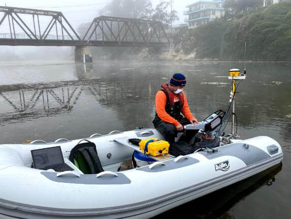
Surveyors use echo sounders, either single-beam or multi-beam, mounted on vessels or unmanned surface vehicles to scan the survey area.
As sound waves reflect off the seabed or riverbed, the time taken for the signal to return is used to calculate depth, while GPS data ensures the location of each reading is precisely georeferenced.
Since visual observation below water is limited, this method provides the only practical way to build accurate models of submerged surfaces.
What Does a Hydrographic Survey Involve?
A hydrographic survey involves site assessment, equipment setup, and sonar scanning using a boat or surface vessel.
The process begins with risk planning and tide analysis, followed by mobilisation of a survey team with sonar systems, GPS receivers, and motion sensors.
During the survey, sonar pulses are emitted and recorded across a grid pattern, creating detailed depth profiles and seabed maps.
Data is processed using hydrographic software to produce 2D charts or 3D terrain models, which can be used for design, compliance, or volume calculations.
Since water movement and environmental conditions affect data quality, surveys are timed to align with favourable weather and tidal conditions.
When Is a Hydrographic Survey Needed?
A hydrographic survey is needed when underwater measurements are required to support planning, maintenance, or construction near or within a water body.
Projects that typically require hydrographic surveys include dredging works, bridge construction, flood defence schemes, reservoir management, and marine engineering.
Since underwater features can shift significantly over time, pre- and post-construction surveys help document changes and validate that works have been completed to specification.
What Equipment Is Used in Hydrographic Surveys?
Hydrographic surveys are conducted using a range of high-precision instruments including echo sounders, GNSS positioning systems, motion sensors, and data loggers.
Single-beam echo sounders are used for basic cross-sectional depth readings, while multi-beam systems provide full seabed coverage and 3D bathymetric outputs.
GPS receivers, often operating on RTK networks, provide real-time positional data to tie sonar readings to precise locations.
Inertial motion units are used to correct for vessel movement, and tide gauges or vertical reference models are applied to ensure consistent depth measurements.
Since each site has different survey needs, the exact combination of equipment is chosen based on the water depth, access limitations, and required accuracy.
How Accurate Is a Hydrographic Survey?
A hydrographic survey is highly accurate when conducted with professional-grade equipment and experienced operators.
Multi-beam sonar systems paired with RTK GNSS can achieve horizontal accuracy within 10 to 20 millimetres and depth accuracy within approximately 10 millimetres, depending on conditions.
Since water levels fluctuate and can distort raw measurements, tide corrections or reference frames such as VORF are used to standardise results.
The final output meets accuracy standards suitable for engineering design, navigation safety, and regulatory compliance.
How Long Does a Hydrographic Survey Take?
The duration of a hydrographic survey depends on the size of the area being surveyed, access arrangements, and environmental factors.
Small-scale surveys on inland water bodies can often be completed in one to two days, while larger coastal or marine sites may require several days or more.
After the fieldwork is complete, data processing and reporting generally take between five to ten working days, although fast-track delivery is available for urgent projects.
Since tides, weather, and boat mobilisation affect scheduling, each survey is planned to minimise delays and optimise data quality.
How Much Does a Hydrographic Survey Cost?
The cost of a hydrographic survey starts from around £1,500 to £3,000 for small inland lakes or rivers with simple requirements.
More complex projects, such as large-scale harbour surveys, multi-beam scanning, or integration with construction monitoring, can range from £5,000 to £20,000 or more.
Final pricing depends on area size, required equipment, data resolution, and deliverables such as CAD charts, terrain models, or volume calculations.
Since every site presents different challenges, quotes are tailored to reflect project scope, risk, and access logistics.
What Are the Benefits of a Hydrographic Survey?
Hydrographic surveys offer precise, real-world data that supports design, construction, and safety in and around water environments.
The key benefits include:
- Enables accurate planning of dredging, piling, or underwater construction
- Identifies submerged hazards before work begins
- Helps manage flood risk and water capacity in reservoirs or rivers
- Supports safe navigation through channels or ports
- Provides volumetric data for sediment removal or fill operations
- Delivers verified “as-built” records after marine works
- Assists with environmental assessments and compliance reporting
As underwater conditions are dynamic and often unpredictable, accurate surveys reduce uncertainty and support effective decision-making across marine and infrastructure projects.
Can Hydrographic Surveys Be Combined with Other Services?
A hydrographic survey can be integrated with topographical, geotechnical, or utility surveys to deliver a complete understanding of site conditions above and below water.
Since many engineering schemes require both terrestrial and aquatic data, such as bridges, flood barriers, or quay walls, combining services ensures continuity across disciplines.
Survey data can be delivered in CAD, GIS, or BIM formats for use by architects, planners, and engineers.
Can a Hydrographic Survey Be Conducted on a River?
A hydrographic survey can be carried out on rivers, provided the water body is navigable by a survey vessel or unmanned surface vehicle.
Since rivers are subject to seasonal flow variations, sediment build-up, and bank erosion, surveys are often needed to assess navigational depth, inform flood modelling, or plan channel maintenance.
As river conditions may change rapidly due to rainfall or tidal inflows, surveys are typically scheduled during periods of stable water level to maximise accuracy.
What Is the Difference Between Single-Beam and Multi-Beam Surveys?
A single-beam survey collects depth data directly beneath the survey vessel in a single vertical line, while a multi-beam survey captures a fan-shaped swath of data across the full width of the water body.
Since multi-beam systems generate more detailed and continuous coverage of the seabed or riverbed, they are preferred for engineering, dredging, or volume calculation projects that require high-resolution 3D data.
As single-beam systems are quicker to deploy and more cost-effective for simple depth checks, the choice depends on the project’s data requirements and budget.
Can Hydrographic Investigations Be Done with Drones?
Hydrographic surveys cannot be performed with aerial drones alone, as sonar equipment requires physical contact with the water surface.
Since drones cannot transmit acoustic signals underwater, sonar systems must be mounted on crewed boats or unmanned surface vehicles (USVs) to collect bathymetric data.
As a complement to hydrographic data, drone-based aerial imagery or LiDAR can be used to capture coastal topography or identify above-water features for integrated modelling.
Is Tide Correction Necessary for Hydrographic Survey?
Tide correction is essential in most hydrographic surveys, especially in tidal rivers, estuaries, or coastal waters.
Since water levels rise and fall throughout the day, raw depth readings must be adjusted using tidal gauges, predicted tide models, or vertical datum systems like VORF.
As uncorrected data could result in misleading measurements, accurate tide correction ensures all depth values are referenced to a consistent level, such as chart datum or Ordnance Datum.
Can Hydrographic Surveys Be Used for Volume Calculations?
Hydrographic survey data is commonly used to calculate the volume of sediment in dredging areas, water retained in reservoirs, or capacity in settlement lagoons.
Since the digital terrain model (DTM) generated from sonar data shows the elevation of the underwater surface, it can be compared against historical or design models to determine how much material has been deposited or removed.
As accurate volume calculations support construction billing, environmental monitoring, and asset management, hydrographic surveys are an essential part of volumetric analysis.
What Format Are the Survey Results Delivered In?
The results of a hydrographic survey are typically delivered in CAD (DWG or DXF), PDF charts, and GIS-compatible formats depending on client requirements.
Since many clients use the data for design, compliance, or integration into larger models, files can include digital terrain models (DTMs), contour plots, cross sections, and volume reports.
As post-processing involves correcting, filtering, and interpreting sonar data, all outputs are quality-checked before delivery to ensure technical accuracy and usability.
Is a Hydrographic Survey Required for Planning Permission?
A hydrographic survey is not usually required as part of standard planning permission applications unless the development involves construction in, on, or near a water body.
Since projects such as marinas, bridges, flood defences, or outfall structures affect submerged terrain and flow behaviour, local authorities or environmental agencies may request a hydrographic survey to support flood risk assessments or engineering approvals.
As part of a multi-disciplinary submission, hydrographic data supports design compliance and environmental due diligence.
Can Hydrographic Surveys Detect Underwater Obstructions?
Hydrographic surveys can identify submerged hazards such as boulders, wrecks, debris, pipelines, or collapsed structures.
Since sonar waves reflect off solid objects beneath the water surface, these anomalies appear as high points or irregularities in the depth profile or seabed model.
As accurate obstruction detection is vital for marine construction, dredging, or navigation safety, sonar interpretation is a key component of the survey process.
Are Hydrographic Surveys Safe to Conduct?
Hydrographic surveys are considered safe when carried out by trained professionals using proper safety protocols and navigational controls.
Since surveyors operate in potentially hazardous environments, such as tidal waters or fast-flowing rivers, risk assessments, life-saving equipment, and safe access procedures are part of the standard workflow.
As unmanned vessels can now perform surveys in areas unsafe for crewed boats, operational risks are further reduced in complex or high-risk environments.
How Frequently Should a Site Be Surveyed?
The frequency of a hydrographic survey depends on the purpose of the data and the rate of change in the water body.
For navigational channels, routine surveys may be conducted quarterly or annually to monitor silt build-up.
For construction projects, surveys may be carried out before, during, and after works to track progress and confirm design compliance.
Since sedimentation and erosion can alter underwater topography quickly, regular surveys help maintain up-to-date information for critical decision-making.
Request a Free Quote for Hydropic Assessments
A hydrographic survey delivers the underwater intelligence necessary for safe, compliant, and well-informed development in coastal, river, and reservoir environments.
Since what lies beneath the surface is often hidden yet critical to project success, professional hydrographic surveying offers clarity where it’s needed most.
Whether you’re preparing for dredging, marine construction, flood prevention, or environmental monitoring, we provide high-resolution bathymetric data and expert interpretation to meet your goals.
Get a free quote for a hydrographic survey today, and ensure your next marine or freshwater project is grounded in accuracy, safety, and technical excellence.
Find More Info
Make sure you contact us today for a number of great pro hydrographic survey services.
For more information on Pro Hydrographic Surveys, fill in the contact form below to receive a free quote today.
★★★★★
Pro Hydrographic Surveys carried out a detailed multi-beam survey for our flood defence project in Lincolnshire, and the accuracy of their data was exceptional. The team were efficient, well-organised, and kept us fully updated throughout the process. Their final charts and models were precise and easy to integrate into our design software — genuinely first-class service.
Matthew Hensley
Greater London
★★★★★
We appointed Pro Hydrographic Surveys to complete a bathymetric survey of a marina redevelopment in Devon, and they exceeded expectations. The crew were professional, safety-conscious, and delivered high-quality results despite challenging tidal conditions. Their report gave us the confidence to proceed with dredging works on schedule and within specification.
Charlotte Greene
Greater London